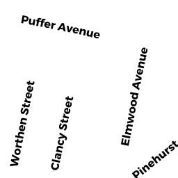
118 ELMWOOD AVENUE
Owner Information
BOISVERT JEANNINE M
118 ELMWOOD AVENUE
SWANSEA, MA 02777 2330


Property Details
118 ELMWOOD AVENUE is classified as a Single Family Residential (Conventional).
The primary structure on this property was built in 1917. There are 2,210ft2 of built area within this property. There is 1,010ft2 of residential/living space within this property. This property is listed as having 5 rooms.
118 ELMWOOD AVENUE is valued at $234,900. The land is valued at $99,200 and the structures are valued at $132,900. There is an additional valuation of $2,800 on this property.
This property is in Zone R1. Confirm with local Zoning Board authorities to ensure there are no overlays or other easements on this property.
The most recent deed for 118 ELMWOOD AVENUE is recorded at the local registrar in Book 4512, Page 0021. 118 ELMWOOD AVENUE was last sold on Monday, September 16, 2002 for $170,000.
Assessment data from fiscal year 2021.
Flood Data
This property is partially within the AE Zone (within floodplain). Approximately 0.07 acres (47.43%) of the property is within this zone.
The base flood elevation for this flood zone is 15 feet.
This information is sourced from the FEMA National Flood Hazard Layer. See our full disclamer.
Broadband Internet Providers
| Provider | Type | Bandwidth (mbps) | |
|---|---|---|---|
| Viasat Inc | Satellite | 100 | 3 |
| Verizon New England Inc. | DSL | 5 | 0 |
| Comcast | Cable | 1000 | 35 |
| GCI Communication Corp. | Satellite | 0 | 0 |
| T-Mobile | Fixed Wireless | 25 | 3 |
| VSAT Systems, LLC. | Satellite | 2 | 1 |
| HughesNet | Satellite | 25 | 3 |
Broadband service provider data from December 2020.
Adjacent Properties
- 133 PINEHURST AVENUE
Single Family Residential owned by ROCKCLIFFE-LEBLANC SUSAN J - 126 ELMWOOD AVENUE
Single Family Residential owned by FRAZIER DAVID & CHERYL A - 114 ELMWOOD AVENUE
Two-Family Residential owned by SANCHEZ JONATHAN J A & - 117 PINEHURST AVENUE
Multiple Houses on one parcel owned by GOUVEIA SARMENTO M